Valle Vista: Birding Hotspot
By Maureen Lahiff
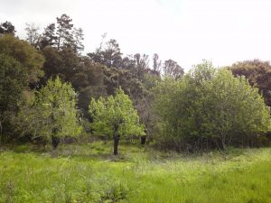
This area—accessible with an EBMUD recreation permit—is sometimes known as Upper San Leandro Reservoir, but the reservoir is just part of the experience. What makes Moraga’s Valle Vista Staging Area a birding hotspot is an amazing array of habitats: grassland, chaparral, riparian willows and alders, redwoods and pines, mixed-forest deciduous trees, and fruit trees left behind by former residents. Oh, and lots of poison oak, whose berries are enjoyed by over 50 species of birds.
Appreciating the land and water
Now managed by the East Bay Municipal Utility District (EBMUD) for watershed protection, the land bears traces of past and current uses. There are bedrock mortars—used by native Jalquin people for pounding acorns—along Moraga Creek, which flows into Upper San Leandro Reservoir. The land to the east was part of the rancho granted to Joaquin Moraga and Juan Bernal in 1835. The Moraga Horsemen’s Association today leases land from EBMUD for horse boarding and riding; they actively manage about 100 acres of pasture near the head of Upper San Leandro Reservoir.
Two major forces have shaped and continue to shape the landscape: trees and water. Their stories are intertwined; as reservoirs were created, trees were planted around them to stabilize the hillsides. I’ve done my best to put together a brief set of facts using Internet resources. I think I’ve got the major sweep of things, but more knowledgeable readers may have facts to add or correct.
The Gold Rush caused a brief period of bustling logging in the hills east of Oakland. As Sylvia Linsteadt writes in Lost Worlds of the San Francisco Bay Area, “by 1854, the biggest trees were gone, and by 1860, all the mills had closed down.” Two of the logging boom towns are now under Upper San Leandro Reservoir; one may have been called Valle Vista. There was a second wave of active logging after the 1906 earthquake. The redwoods we enjoy in nearby Redwood Regional Park are third-growth trees.
Widespread planting of eucalyptus began in 1910, led by the Pacific Water Company. Monterey pines were widely planted around the reservoir in the 1930s by the Soil Conservation Corps. Even if they were not plagued by a fungus causing Pitch Canker, Monterey pines have a relatively short life span. EBMUD is slowly logging out these trees, using mules for hauling. To replace removed eucalyptus and Monterey pine, EBMUD is planting redwood seedlings, grown from locally-gathered seeds.
San Leandro Creek, formerly Arroyo de San Leandro, is about 22 miles long—originating near Round Top in Sibley Regional Park, flowing down the eastern face of the Berkeley Hills and east through the Valle Vista area, then turning south and eventually entering San Leandro Bay. It originally supported runs of chinook and coho salmon and steelhead trout. The first dam built on San Leandro Creek in 1874-75 created a lake called San Leandro Reservoir. It was renamed Lower San Leandro Reservoir when another dam was built about four miles upstream in 1926. Later it was renamed again in honor of Anthony Chabot: It’s now Lake Chabot, part of the East Bay Regional Park District.
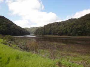
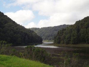
Meanwhile, the newer lake created by the 1926 dam became Upper San Leandro Reservoir—part of this Birding Hotspot. It actually gets most of its water from the Mokelumne Aqueduct.
You can view a very nice map on the Oakland Museum of California web site.
The land around Valle Vista is one ridge over from San Francisco Bay, so it’s exposed to both coastal fog and interior heat.
Who lives here?
Coyote and bobcat, deer and a range of meso-predators, including raccoons, skunks, and snakes. And birds, both resident and migrants who visit for half the year.
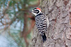
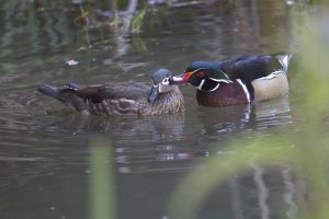
Once you know the landscape, the possibilities for raptors, woodpeckers, chaparral birds, riparian corridor birds, and conifer and mixed forest birds are all apparent. There are Wood Duck boxes on the trees, and boxes for cavity nesters.
Birders’ favorite trail
The parking lot birding is great: Acorn Woodpeckers, American Kestrel, sparrows on the ground, swallows on the wire, sapsucker holes on a tree by the sign-in kiosk. Bovines on the hill, too, and perhaps coyotes demonstrating why they are called song dogs.
Most birders use part of the Kings Canyon Trail. After signing in, I like to head off to the right a bit, getting a bit uphill from the parking lot, and then make a 180 degree turn onto a wide trail that goes through scrub habitat. One of the delights of this stretch is the whiny/wheezy call of the Blue-gray Gnatcatcher.
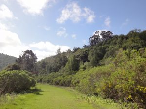
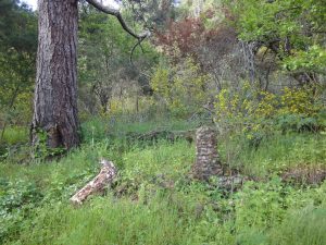
Coming down the hill, there are some remains of a brick stairway off to the right. Then we come to our first chance to sight water, depending on EBMUD water management. The trail continues through scrub/chaparral. This is the best stretch for California Thrasher. Then it’s into the woods, where the somewhat narrow trail is heavily used by runners and dogs on walks (with their people, and on leash). It is still great birding.
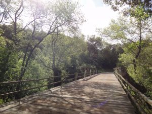
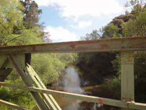
As we approach the bridge, the trail draws near the road and you may hear the gate opening for vehicles heading to the horse pasture and barns. Quiet walkers may be rewarded with a glimpse of the elusive Wood Ducks in the creek.
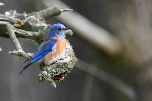
The trail passes a grassy hillside, a perfect place for raptors and Western Bluebirds.
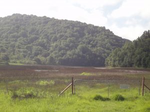
Then the head of the reservoir comes into view. Scopes are welcome for views here.
Most birders turn around at this point, though the trail continues around the reservoir.
A trail map for what I’ve described is on the South Watershed map on EBMUD’s East Bay Trails page.
Fast Facts
The key thing to know about this birding spot is that a recreation permit is required from EBMUD. Permits cost $3 per day, $10 per year, or $20 for three years and $30 for five years. Individual permits cover immediate family and up to three guests. For permit information, see ebmud.com/recreation/.
Madeline Brane and Johan Langewis lead monthly Golden Gate Bird Alliance field trips to Valle Vista. They have trail leader’s permits from EBMUD, so you may join them without your own permit. Check our Field Trips web page to see if a trip is scheduled for the current month.
Location: Canyon Road, Moraga. Google Map: https://goo.gl/maps/zAytMRxsRky
Hours: Sunrise to sunset. There is a sign-in at kiosk by entrance gate
Dogs: On leash on King’s Canyon Trail.
Habitats: chaparral, grassland, pine/redwood, deciduous trees, riparian, head of reservoir
Key Birds:
Year Round: American Kestrel, Red-tailed Hawk, Red-shouldered Hawk; Northern Flicker; Acorn Woodpecker, Nuttall’s Woodpecker, Downy Woodpecker, Hairy Woodpecker; California Thrasher, Wrentit; Blue-gray Gnatcatcher; Red-breasted Nuthatch; Bewick’s Wren, House Wren; Belted Kingfisher; Western Bluebird; Song Sparrow; Anna’s Hummingbird; Great Blue Heron; Wood Duck; Pie-billed Grebe; Band-tailed Pigeon; American Crow, Common Raven; European Starling
Spring/Summer: Wilson’s Warbler, Orange-crowned Warbler; Pacific Slope Flycatcher; Tree Swallow; Allen’s Hummingbird
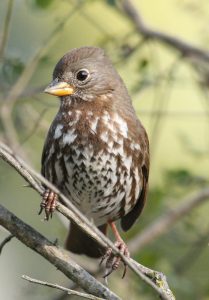
Fall/Winter: Red-breasted Sapsucker; White-crowned Sparrow, Golden-crowned Sparrow, Fox Sparrow; Yellow-rumped Warbler
Getting there:
Take CA-24 to exit 9, the Orinda/Moraga exit, and go south on Camino Pablo, which becomes Moraga Way. Follow Moraga Way to the end. At the T intersection, turn right onto Canyon Road. (The road to the left is Moraga Road.) In a little over a mile, you’ll arrive at the Valle Vista Staging area on the left.
An alternate route from Oakland on small roads involves taking Redwood Road to Pinehurst Road (turning left just east of the Redwood Regional Park entrance), then right on Canyon Road to the staging area.
The parking lot is not paved, and has some deep ruts, thanks to winter rains.
Restrooms: Chemical toilet in the parking lot. Water is not available.
Nearby cafes/restaurants: Not many options. Ranch House on School Street off Moraga Way for breakfast and early lunch, open 8 to 1:30 every day. Bianca’s Deli and Catering in Moraga Center at the corner of Moraga Way and Moraga Road, cash only, open 9 to 5, Mon-Sat, closed Sun.
For more information: ebmud.com/recreation/
Maureen Lahiff, Chair of Golden Gate Bird Alliance’s Adult Education Committee, is a member of the inaugural Master Birder class taught by GGBA in 2013. She is part of the Vaux’s Swifts counting team, serves as a docent at Lake Merritt, leads GGBA field trips, and teaches GGBA adult ed classes.